GBR catchment area Grid-to-Grid (G2G) surface flows with eReefs GBR4 Hydro salinity (AIMS, Source: CSIRO, BOM)
Preview image of the full visualisation videos. Please open the downloads below to access the actual videos.
Open full visualisation downloads (MP4)
When using this visualisation, please cite: Hammerton, M., Lawrey, E., Lafond, G. (2026). GBR catchment area Grid-to-Grid (G2G) surface flows with eReefs GBR4 Hydro salinity (AIMS, Source: CSIRO, BOM). eReefs AIMS Visualisation Portal. https://ereefs.aims.gov.au/gbr4_v4/surface-flow-and-ocean-salinity/
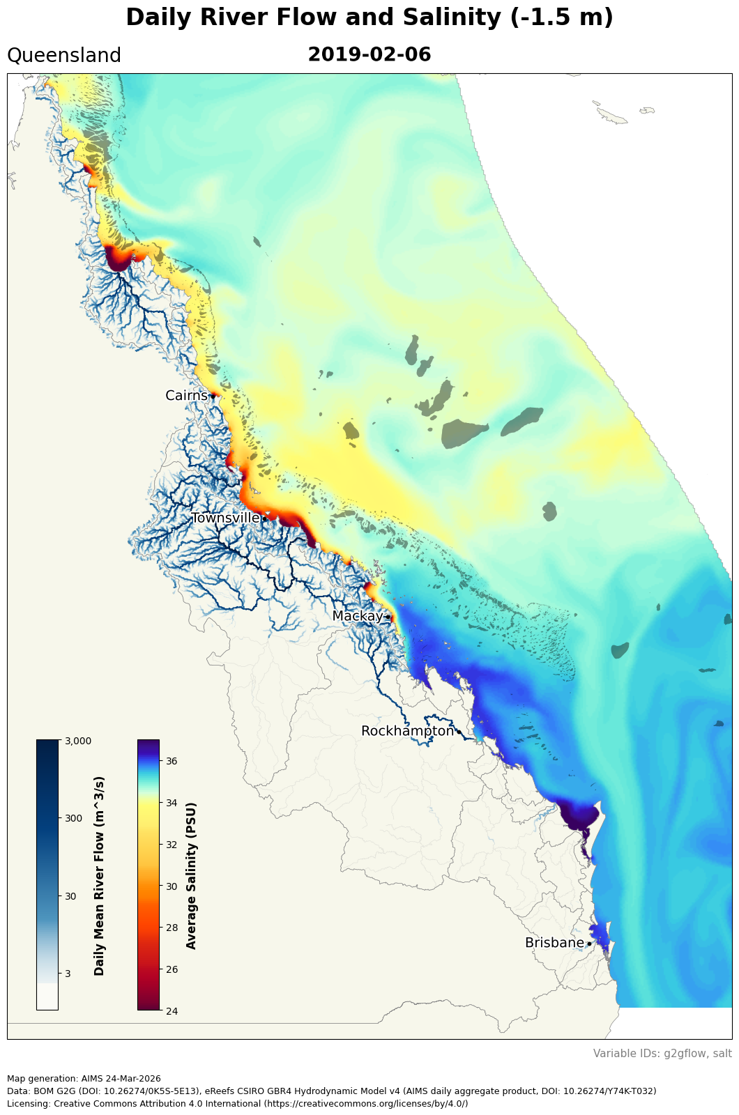
This visualisation combines catchment surface flow from the Grid-to-Grid (G2G) model with marine salinity from eReefs GBR4 Hydro to show how land runoff events influence coastal ocean conditions across the Great Barrier Reef. During high rainfall and flood events, increases in land and river surface flow are associated with lowered salinity in adjacent marine waters, making plume pathways and regional influence patterns easier to interpret.
It is designed as an integrated land-to-sea view. The G2G layer highlights where freshwater is generated and routed through catchments, while the salinity layer shows the corresponding marine response.
G2G surface flow
The g2gflow variable represents modelled surface freshwater flow across GBR catchments, including river flow and ungauged overland runoff routed toward the coast. In the published dataset this variable is provided as daily NetCDF grids (daily averages from hourly source data) with units of cumecs (\(m^3/s\)).
In this visualisation, higher g2gflow values identify where rainfall-driven runoff and river discharge are most intense, helping to show which catchment areas are contributing freshwater to marine waters during flood events. It should be noted that the model was tuned for generating correct river mouth flow rates, not flow rates far from the coast.
Salinity
Salinity is a measure of the saltiness of seawater. Freshwater outflow from rivers and runoff lowers coastal salinity, so low-salinity areas are a practical indicator of flood plume influence. In this combined view, the marine salt field from eReefs GBR4 Hydro is shown alongside g2gflow so you can directly compare runoff intensity on land with decreasing salinity in adjacent coastal waters.
During high-flow periods, salinity reductions become more extensive along the coast and may spread further offshore depending on prevailing wind and circulation conditions. This makes the salt layer useful for understanding the ocean response to catchment runoff events and for tracking the relative footprint of plume conditions in reef-adjacent waters.
Source data
The visualisation combines:
- Daily 1 km G2G surface flow dataset for GBR catchments (DOI: 10.26274/0K5S-5E13).
- eReefs GBR4 v4 daily hydrodynamic salinity from the AIMS THREDDS server.